


TreeNet: An AI-Powered Software for Individual Tree Detection and Forest Inventory Using UAV LiDAR Data
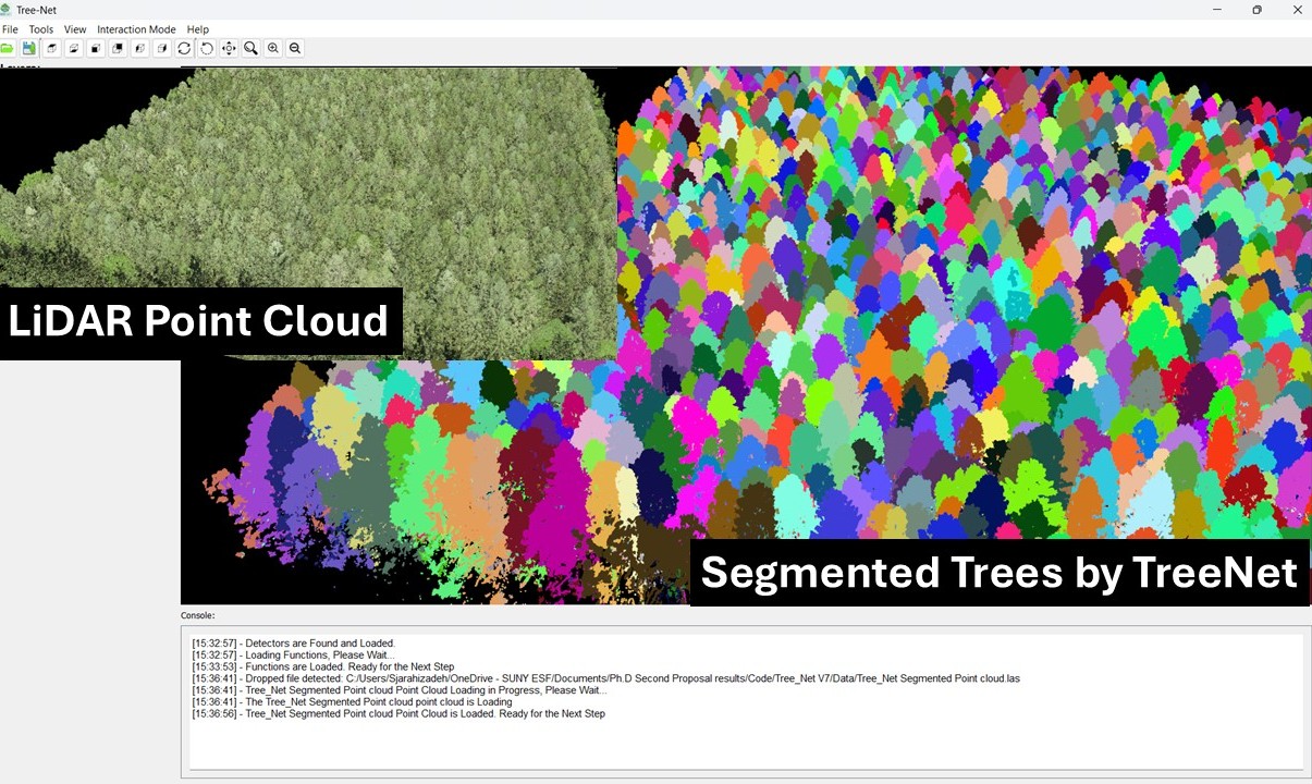
TreeNet is an AI-powered software solution designed to automatically detect, segment, and analyze individual trees using UAV-collected (drone) LiDAR and photogrammetric point clouds. Developed by Sina Jarahizadeh and Bahram Salehi, TreeNet provides intelligent measurements of tree height, crown area, structural attributes, biomass, and species across both urban and forested landscapes.
TreeNet leverages a novel deep learning architecture inspired by single-stage object detectors. This enables high accuracy, adaptability to diverse environments, and user-friendly operation. Unlike conventional methods-which rely on manual fieldwork or generic 2D canopy tools-TreeNet offers a fully automated approach that significantly reduces the time, labor, and cost associated with tree-level analysis at scale.
What sets TreeNet apart is its ability to perform individual tree segmentation and attribute extraction on a large scale-something not achievable with existing tools. Traditionally, this work has required human operators to measure trees manually in the field. TreeNet eliminates that need by automating the entire process through advanced AI.
To date, we have developed and implemented TreeNet as a functional software toolkit and validated its performance across a variety of real-world environments.
Designed for seamless integration with drone platforms, TreeNet empowers government agencies, environmental organizations, industry professionals, and researchers to make better-informed decisions through high-resolution, AI-driven forest intelligence.
TreeNet serves a diverse range of customers across government, environmental, and private sectors who require accurate, scalable, and cost-effective tree-level data at large scale. Some of the potential customers include:
- Drone service providers
- Timber and forestry companies
- Urban planners, landscape architects, and green space managers
- Environmental consulting and carbon offset firms
- Municipalities and urban forestry departments
- Government agencies (e.g., US Forest Service)
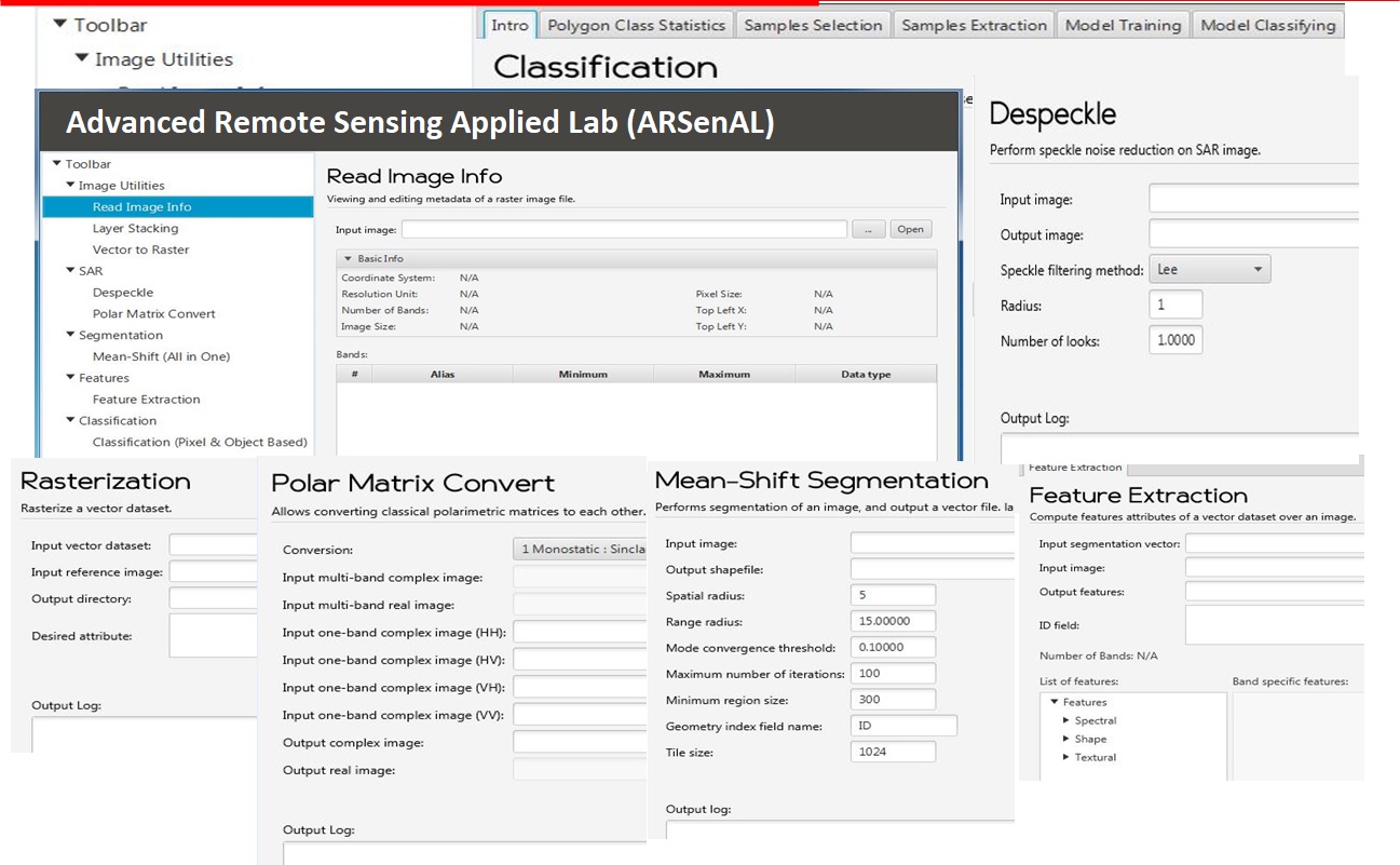
Software: Advanced Remote Sensing Applied Lab (ARSenAL):
ARSenAL is an advanced remote sensing toolbox, developed by Dr. Salehi and his team, comprising several algorithms for processing SAR and optical imagery. Algorithms include Segmentation, Feature Extraction (Spectral and Textural), Object-based Random Forest Classification, SAR speckle filtering and decomposition, a genetic-based feature extraction for random forest classification of wetlands, etc.
A Wetland Inventory Model for Newfoundland and Labrador:
Developing a Wetland Inventory System for Newfoundland and Labrador using Advanced Remote Sensing Technologies.Visit the website
Wetlands: Nature's Kidneys
The most biologically diverse of all ecosystems, wetlands play an important role in environmental health, contributing to water purification, flood control, and shoreline stability, as well as providing habitat for a wealth of plant and animal life. Yet wetlands in boreal systems remain poorly understood. Today, new technologies are offering the potential to map our province?s wetlands in a thorough, detailed and cost-effective manner.

Project overview
Canada owns approximately 25% of the world's total wetlands. Newfoundland and Labrador is one of the most wetland-rich provinces in Canada, but it is the only province in Atlantic Canada that lacks a wetland inventory system. Led by C-CORE?s Dr. Salehi as principal investigator, a team of his Ph.D. and MSc students in Memorial Universities Faculty of Engineering and Department of Geography have developed an advanced and semi-automatic remote sensing image processing framework for wetland classification. The framework comprises multiple algorithms including segmentation, feature extraction, and random forest classification to map wetlands and classify them into five major wetland classes according to the Canadian Wetland Inventory system: bog, fen, marsh, swamp, and shallow water.
The project is broadly collaborative, engaging a wide range of partners: C-CORE and several federal and provincial organizations including Environment and Climate Change Canada, Canada Centre for Remote Sensing, Ducks Unlimited Canada, the Provincial Department of Environment and Conservation Wildlife Division and Water Resource Management Division, and Nature Conservancy Canada. Several peer-reviewed journals and conference publications have been derived from this work, most are listed on this website and available online or by request to Dr. Salehi. The method has been developed and tested on five sites across the province and now we are in the phase of automatic generation of provincial wetland inventory and wetland monitoring.

Acknowledgements
This project was undertaken with the financial support of the Government of Canada through the federal Department of Environment and Climate Change, the former Research & Development Corporation of Newfoundland and Labrador - RDC (now InnovateNL), and Ducks Unlimited Canada. The SAR imagery was provided by the Canada Center for Mapping and Earth Observation and Environment and Climate Change Canada. Field data was collected by various organizations including, Ducks Unlimited Canada, Government of Newfoundland and Labrador Department of Environment and Conservation, and Nature Conservancy Canada. We thank these organizations for the financial supports and providing such valuable datasets.
Visit the website
